Fieldwork took place in October and November 2021, as part of the Odyssey 2025 Project led Humanity & Inclusion (formerly Handicap International, HI), partnering with Norwegian People’s Aid (NPA), two well-known INGOs in the humanitarian mine action (HMA) sector. Synergy was achieved by combining specialised technical and scientific knowledge from Mobility Robotics, together with INGOs who work at the pointy end of humanitarian action.
The approach was empirical, not theoretical – using an evidence-based approach. The article was written in plain English, simplifying a lot of the complex background science to encourage other HMA actors to also conduct baseline trials – as a way of gaining knowledge required to determine if TIR sensors can be practical as a HMA tool in each geographic region.
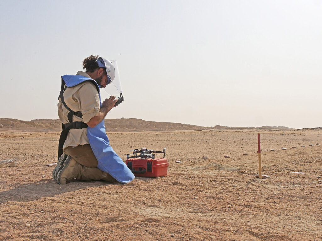
This project provided a blueprint regarding how collaborating can help the HMA sector in general. NPA hosted baseline TIR field trials in Al-Bussayah, southern Iraq, with logistical and technical support provided by their operations, clearance, and survey teams. Valuable expertise was provided by NPA specialists who provided access to confirmed hazardous areas, weathered targets, an open desert location to establish the study area, and security to watch over the site.
Key findings from the Al Bussayah (southern Iraq) baseline TIR field studyin Oct/Nov 2021 were that:
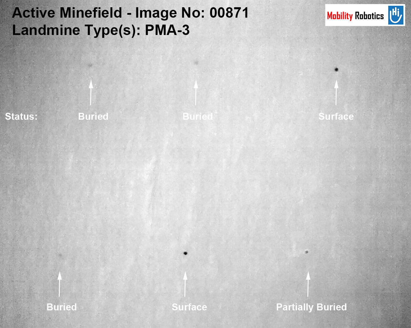
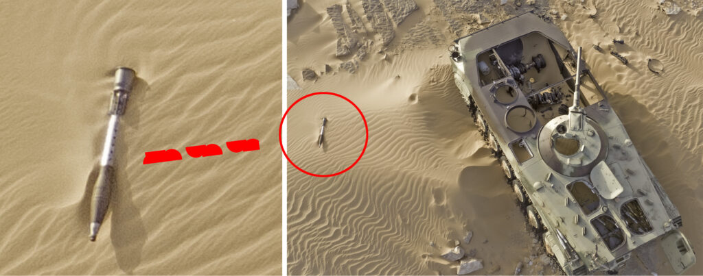
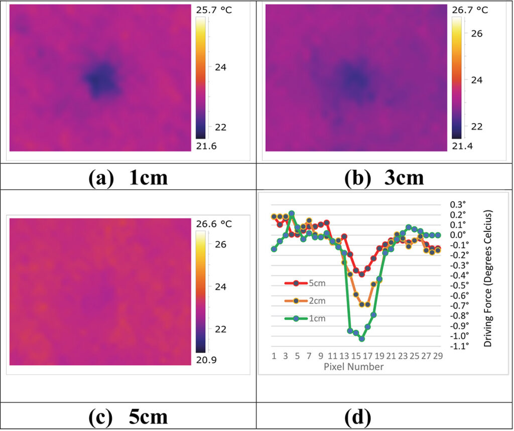
TIR anomalies from buried cluster munitions, AP landmines and ERW not visible to the naked eye could be captured indicating their position under favourable conditions.
TIR anomalies from buried cluster munitions and ERW were captured by the sensor for most of the night in both soft sandy and hard concreted ground found in the area, apart from when it was windy.
TIR anomalies from buried AP landmines were visible to the sensor for extended periods during the night, apart from when it was windy.
TIR anomalies (all targets) from soft sandy ground were clearer than from hard, concreted ground.
Even though patchy at times, TIR anomalies from buried cluster munitions were visible for several hours during the day in sandy ground during favourable conditions.
TIR anomalies from all targets buried in sandy ground appeared for a shorter time during the day than at night.
TIR anomalies from all targets were generally weak during the day in hard ground.
Wind gusts had a detrimental effect on the ability of the sensor to capture TIR anomalies.
Work has continued in 2022, with two more baseline TIR sensors trials in the Middle East covering metal anti-tank landmines, IED componments and improvised landmines.
Targets were buried in a fifth location (and fourth country) last week to continue our empirical, field driven approach. Data will be recorded in July/August, after targets soak in. More on later studies shortly.
This is the presentation by John Fardoulis of Mobility Robotics from April 22nd, 2021 during the ICRC and GICHD webinar on: The Use of Remote Sensing and AI in the Mine Action Sector.
The presentation takes an in-depth look at breakthroughs using thermal imaging to find buried landmines from small drones in a desert environment, plus a more general look at the state of small drone remote sensing in humanitarian mine action (HMA).
Breakthoughs took place as part of the Odyssey 2025 Project which was delivered together with Humanity & Inclusion/Handicap International, under the auspices of the High Commission for Deming in Chad, the HCND, funded by the Belgian Department of Foreign Affairs and the European Commission.
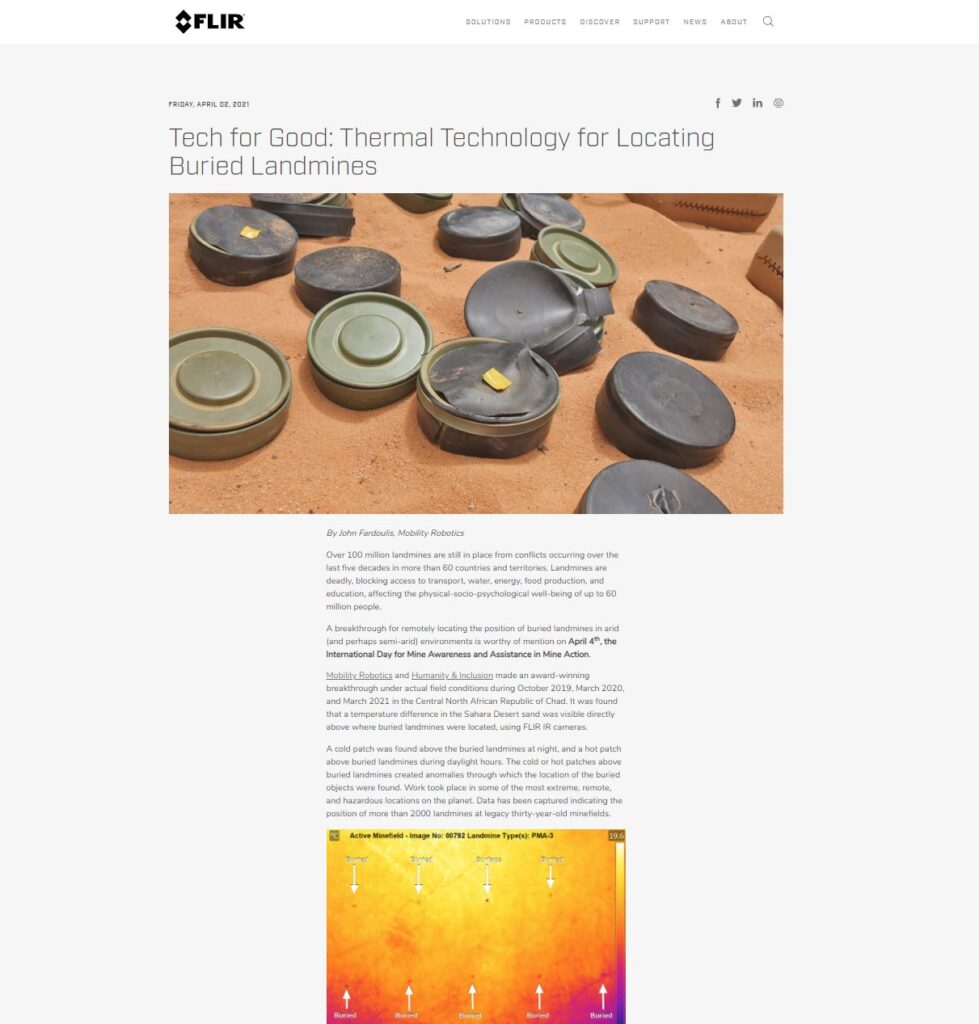
We’re pleased to announce that sensor manufacturer FLIR Systems will be supporting our research and the humanitarian mine action sector more generally – to help improve methods using thermal technology for locating landmines and explosive remnants of war that cause human suffering and contaminate land decades after conflicts have ceased.
Above is the link to the presentation by John Fardoulis of Mobility Robotics from January 14th, 2021 during a webinar: The Certain Conventional Weapons Convention at 40: Evolution, Continued Relevance, Context, and Challenges organised by the Swedish Defense University and the United Nations Office for Disarmament Affairs (UNODA).
It might look easy, but context is of the utmost importance, putting the pieces of humanitarian mine action (HMA) the jigsaw puzzle together to actually achieve positive impact from the applied use of technology and innovation, under real-world field conditions.
The first part provides examples of typical technology and processes used in the field in during HMA work. The second part provides examples of how the use of a relatively new technology to HMA, small drones can make a difference. Lessons from the field are presented from the Odyssey 2025 Project which was delivered together with Humanity & Inclusion/Handicap International (www.hi.org), and the High Commission for Deming in Chad, the HCND. It was a project funded by the Belgian Department of Foreign affairs which ran in Chad from October 2018 until March 2020.
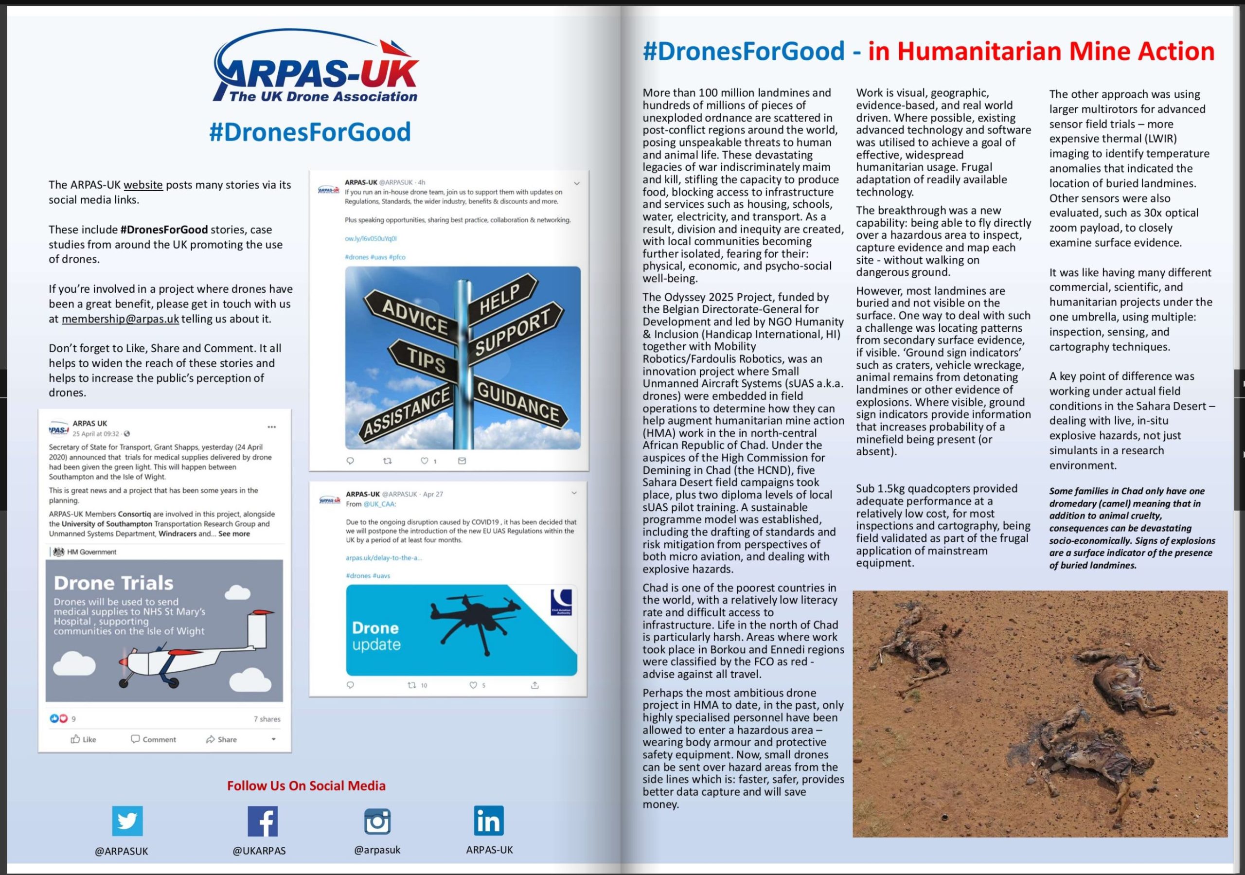
More than 100 million landmines and other items of explosive ordnace (EO) are still scattered around the world today, posing unspeakable threats to human and animal life. Such a devastating legacy of war maims and kills, stifles the capacity to produce food and blocks access to infrastructure and services including; schools, water, electricity and transport for decades after conflict has ceased. As a result, inequities are fostered and local communities fearing for their physical, economic and psycho-social well-being are further isolated.
A focus of the article was in presenting real world proof regarding how small drones could locate buried landmines in the Sahara Desert, Northern Chad using IR thermography. A breakthrough after more than 30 years of speculation regarding the potential for IR thermography as a technique for locating buried landmines in arid environments. The concept is not new, however – there has been a lack of real-world proof to back up claims, which was addressed in a second, editorial piece titled Time to Stem Lightweight Approaches and Focus on Real Minefield Data?
Pathways to Impact
Sharing learnings is important in terms of pathways to impact across the humanitarian mine action (HMA) sector, leveraging funding from the donor, the Belgian Department of Foreign Affairs beyond a single project. Ideally acting as a catalyst that prompts future breakthroughs from many different HMA operators in arid (and perhaps semi-arid) environments to help beneficiaries around the world.
This was a milestone article, creating a new state-of-the-art in knowledge – in practical, field-ready, real-world ways. Ideally kickstarting activities that save lives and limbs, accelerating the land release process, and enabling better productivity at a scale of millions of dollars a year.
The choice of journal was important, as the JCWD spans beyond academia, with extensive reach across the HMA sector – which will resonate at all levels in HMA, from technical specialists in the field through to head office managers, and donors. Peer reviewers for journal were also HMA subject matter specialists, critiquing in practical, relevant ways.
Collaborative Approach
One of the fulfulling parts of the Odyssey 2025 Project was that results were not achieved alone. John Fardoulis/Mobility Robotics took the HMA project partner, Humanity & Inclusion (HI) along a journey that achieved ground-breaking results. The High Commission for Demining (HCND) in Chad and national staff were also important partners along the journey, with a drone programme implemented in a country without any regulations for using such equipment.
The following 10 minute presentation provides an overview, including examples of methodology developed by Mobility Robotics together with HI.
The Odyssey 2025 Project in Chad ended in March 2020, meaning that it is time to create new projects, in new countries. Trailblazing and creating operational capacity in post-conflict zones – making a difference to the world in challenging, often hazardous environments.
We were delighted to present at the World of Drones and Robotics Congress #WoDRC in Brisbane, Australia today – outlining how small drones can make a difference in humanitarian mine action (HMA).
A copy of the presentation can be seen from the link below.
The first part explains why HMA is necessary in over 60 countries and territories around the world, followed by examples and lessons from the field regarding how small drones can help in HMA. Basically a short case study, with real-world examples from work that took place under challenging: harsh, remote and hazardous conditions in the Sahara Desert in Chad from January 2019 until March 2020.
Small drones don’t work in isolation but can help to augment activities inolving: manual demining (human), mechanical and animal assets to improve productivity and capture additional dimensions regarding evidence and data.
Institutional support, embedded field trials, capacity building – including the development and delivery of two diploma levels of training for national indingenous staff, equipment selection and more advanced remote-sensing research was provided by Mobility Robotics during the Odyssey2025 Project in Chad together with Humanity and Inclusion (www.hi.org).
The project was based on the challenge of finding practical, innovative ways to help improve safety, reduce costs and speed up the process in dealing with post-war landmine and explosive ordnance (EO) contamination in developing countries.
More than 100 million landmines and other items of explosive ordnace (EO) are still scattered around the world today, posing unspeakable threats to human and animal life. Such a devastating legacy of war maims and kills, stifles the capacity to produce food and blocks access to infrastructure and services including; schools, water, electricity and transport for decades after conflict has ceased. As a result, inequities are fostered and local communities fearing for their physical, economic and psycho-social well-being are further isolated.
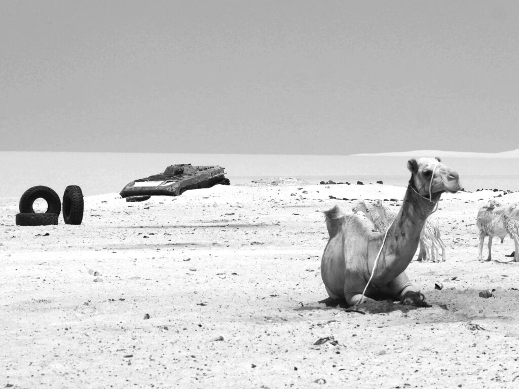
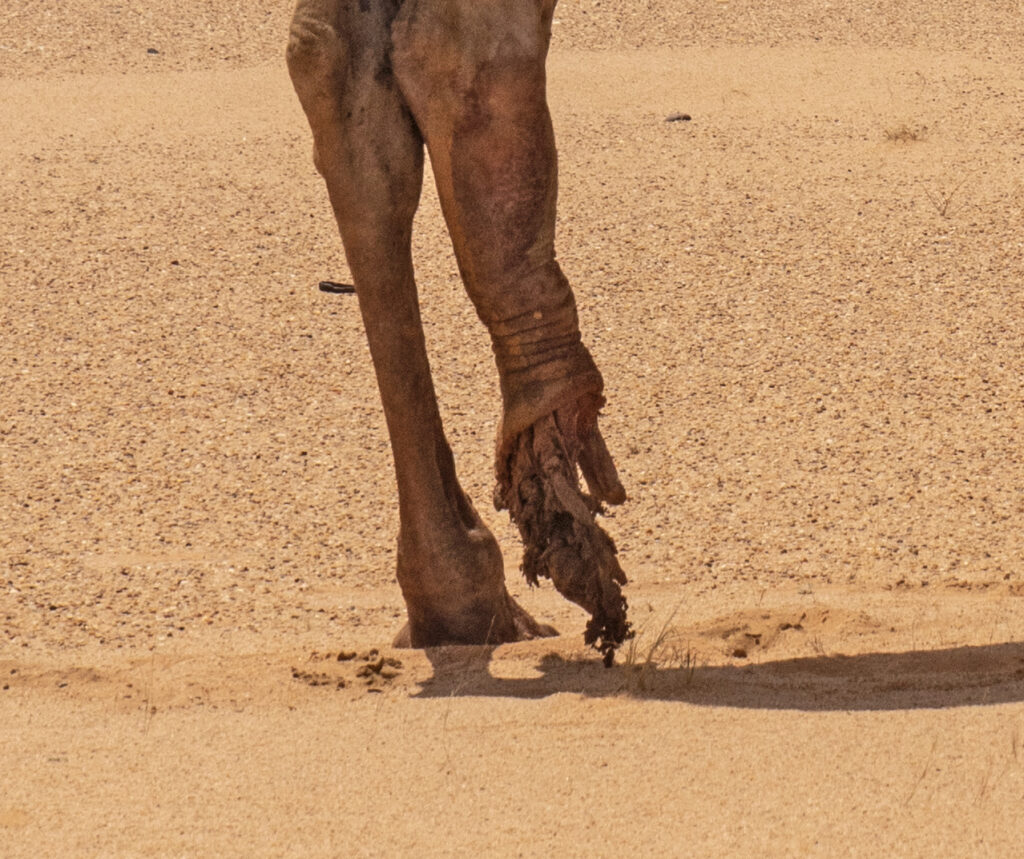
Landmines indiscriminately maim and kill. We saw many camels lose parts of limbs from stepping on landmines (which ultimately meant losing their life) when we were working in the field.
John Fardoulis from Mobility Robotics was the drone lead and primary facilitator, developing strategy and implementing drone work packages for the Odyssey2025 Project.
HI contracted Fardoulis and Mobility Robotics as a project partner to leapfrog their position in the HMA sector. Fardoulis/Mobility Robotics facilitated the creation of a drone strategy in Chad which transformed HI from being an operator without any prior experience, to becoming a world leader in using drones in HMA during 2019-2020.
Winning the EIC Horizon Prize in September 2020 was proof of the results provided by Fardoulis/Mobility Robotics. Fardoulis wrote more than 80% of the EIC Prize application for HI, and was an expert who answered questions by EIC jurors during the final panel review session.
Fardoulis/Mobility Robotics was responsible for; drone innovation strategy creation, methodology design, applied research, training and field validation – using very specialized skills and expertise which enabled HI to achieve a real world impact. HI gained access to Mobility Robotics intellectual property and Fardoulis’ expertise in the fields of: science in extreme environments, strategic planning, remote-sensing, GIS/cartography, drone operations/service provision, aerospace engineering & robotics, procurement, computing, data processing, training, outreach and communication.
Work packages included;
Institutional support: for national, regional and local authorities – especially in developing a standard operating framework, training and competency requirements for drone operators in Chad. Drafting standards based on best practice around the world. There are no formal drone regulations in Chad and drone usage is almost non-existent, hence institutional support was critical as part of a partnership with national, regional and local authorities.
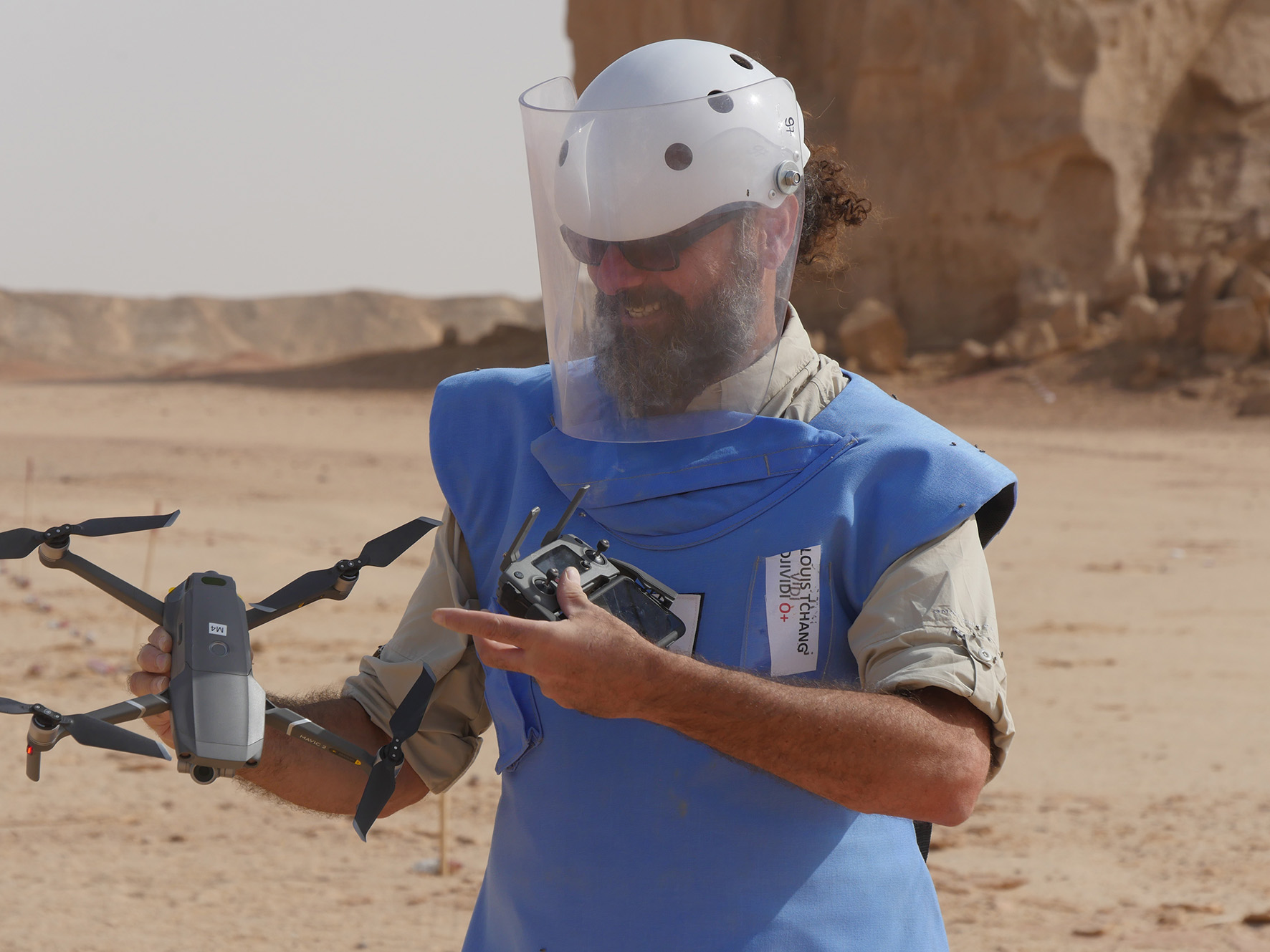
Wearing body armour and personal protective equipment when operating at locations where unintended detonations could be a risk to personal safety.
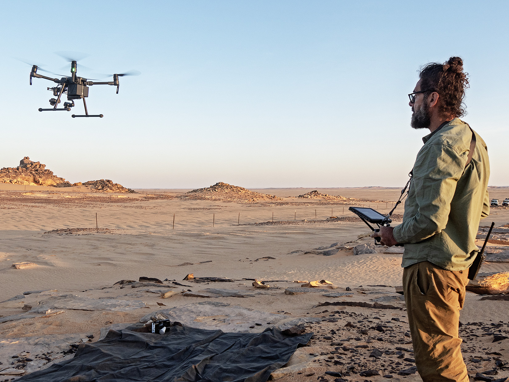
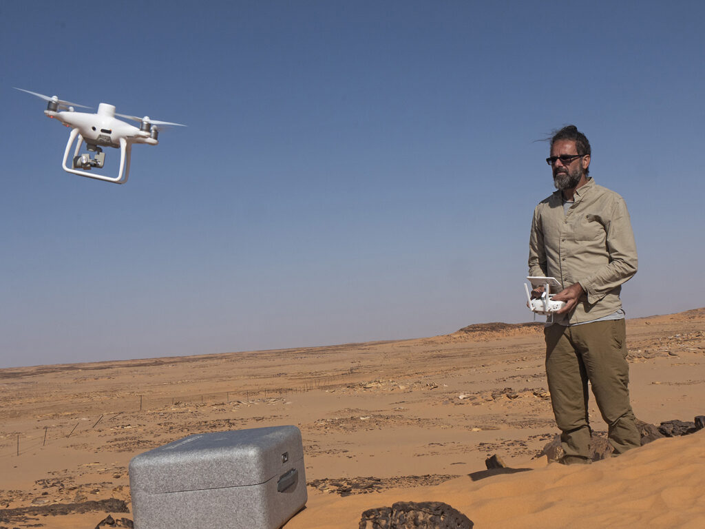
Fardoulis conducted embedded field trials at more than 50 locations – in extreme Sahara Desert conditions – at minefields and suspected hazardous areas. More than 50 linear kilometres of minefields and suspected hazardous areas were mapped from small drones (a world first at such a scale), as well as extensive thermal/LWIR imaging field validation at real minefields. Camping inside active minefields in the desert at times, during 51 degree C heat, travelling for days in places without formal roads, coping with water and food challenges, as well as violent sandstorms.
Field validating a range of consumer, survey, industrial drones, and sensors at remote locations in the Sahara Desert contaminated by explosive hazards.Finishing work at dawn, after operating over minefields, capturing thermal imaging data at night.Real world, post war explosive hazards.
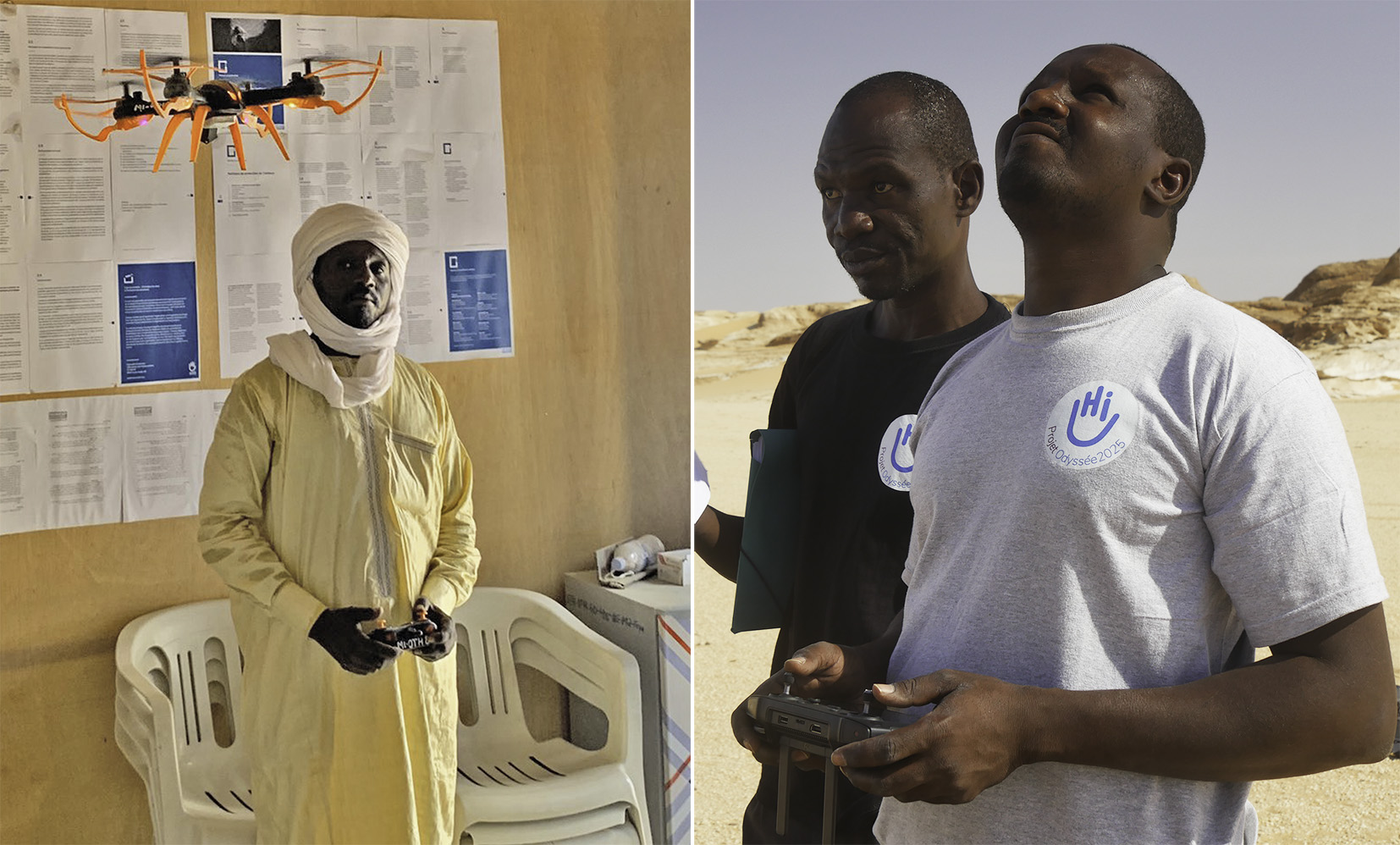
Training national indigenous staff in the use of drones – assuring their competency and abilities to independently operate drones under stressful conditions: at minefields and other hazardous areas. Two humanitarian mine action (HMA) drone operator diploma level training courses were written and delivered.
The Level 1 course was an equivalent of a UK CAA PfCo, USA Part 107, Australian RePL. Level 2 provided skills in flight planning by creating polygons in Google Earth and conducting automated flights, closer proximity operations, photogrammetry processing, creating GIS/Google Earth outputs, exporting imagery outputs for cartography, plus a practical first level of data analysis.
Diplomas were endorsed and jointly issued by the high commission for mine action in Chad, the HCND.
Creating local competency was essential.Graduates of the HMA drone operator courses were deployed to work independently at deadly minefields.These are the people who visit life-threatening minefields on a regular basis.
Equipment & technology selection: particularly the frugal use of off-the-shelf camera drones for inspection of, and mapping minefields. Using relatively low cost, off the shelf consumer equipment means: compact designs, an accelerated launch, ease of use, the ability to scale up, the ability to run over a shorter product life cycle, and greater flexibility regarding repairs and maintenance.
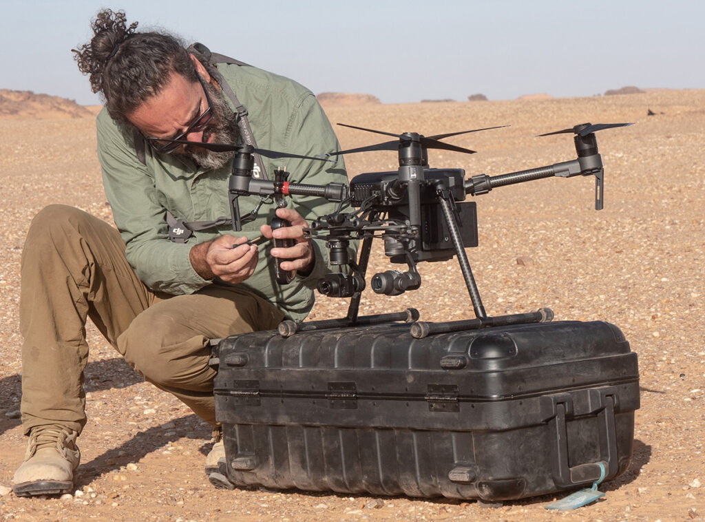
There were also responsibilities in selecting more advanced equipment – such as thermal imaging, survey and industrial drones and payloads. IT hardware and software were also selected for data processing – such as a powerful desktop workstation designed for use at a semi-offline desert base and powerful gaming laptops for use in the field.
Novel research:jointly achieving a world-first with HI – in using small drones to locate buried landmines in the Sahara Desert using thermal/LWIR imaging. At live, in-situ 30-year-old legacy minefields. Not just proof-of-concept but field validation, locating the position of more than 2500 active landmines across ten different locations. This moved the needle in a practical way after 20+ years of speculation by researchers.
Science in remote locations, under extreme conditions , managing the threat from deadly hazards.Capturing thermal anomaly data from small drones which no one has done at Sahara Desert minefields before we started in October 2019.
Another breakthrough was in the design of an automated static field test site providing very high spatial and temporal resolution thermal/LWIR imaging data (capturing data 24 hours a day, 7 days a week). It was designed and prototyped in Australia, then validated at actual minefields in the Sahara Desert, 300km south of the Libyan border with Chad. Such field test sites could be deployed in dozens of arid/semi-arid locations around the world to determine whether thermal/LWIR imaging is viable in each location. Being able to pinpoint where contamination exists in using a near-earth form of remote-sensing such as thermal/LWIR imaging from small drones could save millions of dollars and speed up remediation processes by years.
Advanced flight operations: were undertaken successfully and safely by Mobility Robotics which included 50+ small drone missions over minefields at night. Plus beyond visual line sight (BVLOS) operations over minefields during daylight hours and at night.
Pathways to impact: authoring two peer-reviewed journal articles explaining how breakthroughs were made under actual field conditions (in the desert with real landmines – real explosive hazards), a review article examining state-of-the-art knowledge regarding the use of thermal/LWIR imaging – outlining the direction the HMA sector should take to move forward, and several other articles currently in the pipeline. The greatest immediate impact was by shifting from a need to employ foreign staff to capture visual imagery from small drones, to creating local competency – where equipment and skills transfer was provided in-country.
Longer term, proving field validation that thermal/LWIR imaging is viable for locating buried landmines from small drones will also impact the humanitarian mine action (HMA) sector in a positive way.
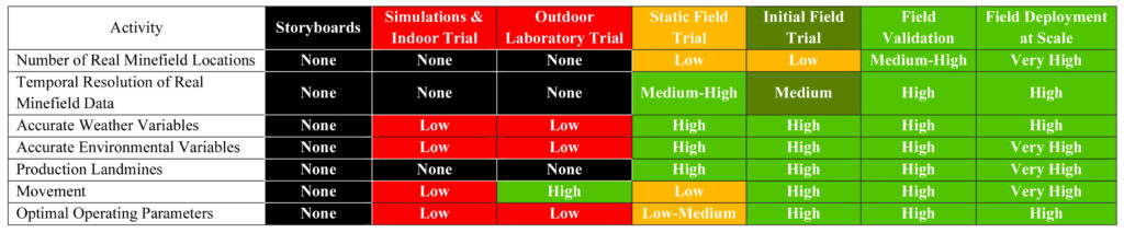
Table 1: the level of proof under actual field conditions provided by each step of key research processes. It is an adaptation of the concept of technology readiness levels (TRL) – in a more holistic way – more so examining ‘field deployment readiness levels’. The closer to field deployment at scale, the greater the real-world impact. We reached field deployment at scale in the use of visual imagery and a field validation stage for thermal/LWIR imaging from small drones.
Advocacy & outreach: at local, regional and national levels in Chad. Also, internationally – providing hard evidence to help the HMA sector gain confidence in the use of small drones in hazardous areas around the world.
The EIC Horizon prize was awarded due to being the best entry in the Open category, addressing the following criteria:
1. Being a new solution tested successfully and safely in a real environment, with a demonstrated potential of adaptability and scalability under different humanitarian aid settings
2. Quality and sustainability of the solution based on the frugal application of advanced technologies
3. Affordability and cost-effectiveness (for beneficiaries and organisations responding to crises)
4. Engagement with end users and solution responding to the needs of those in a most vulnerable situation (taking age, gender, disability and minority into consideration) and perspective of a business case
We are extremely grateful to the European Commission, EIC staff and judges for awarding us such a prestigious prize.
The Odyssey2025 Project would not have been possible without the donor, the Belgian Ministry of Foreign Affairs (MFA). All work took place under the auspices (and generous support) of the high commission for demining in Chad, the HCND.
Thanks are also in order to HI staff, particularly members of the team in Brussels, Lyon, Chad and PRODECO staff who helped make things possible on the ground, often overcoming gargantuan logistical challenges.
As a small Australian company, it was a privilege to become a catalyst in using small drones to help make the world a better place, applying specialized skills and knowledge: in practical ways, a long way from home – in the Sahara Desert.
Receiving such recognition from the European Commission is a huge honour, which validates how drone work during the Odyssey2025 project was truly innovative and achieved a real-world impact for vulnerable people.
Gaining such recognition helps justify the hardships and sacrifices – travelling to developing countries, dealing with extreme environmental conditions, and helping local populations deal with hazardous contamination in the case of landmines and unexploded ordnance for example.
Determination and technical/scientific know-how helped us achieve to world first research breakthroughs – under actual field conditions.
Also proud of taking drone technology to people had never seen a drone before, prototyping and validating methodology – then teaching local staff how to do everything. Leaving local competency to operate drones over active minefields, which is no walk in the park.
We’re really proud to have an article appear in the ARPAS-UK online magazine this month about the humanitarian mine action Odyssey 2025 drone project in Chad.
We’re grateful to have been recognised by the AAUS – Australian Association for Unmanned Systems in being issued the 2020 Humanitarian Achievement award – for demonstrating the role that unmanned technologies can play in bettering our world. Pioneering the use of drones for humanitarian mine action in Chad has not been easy, the programme has been challenging, but we did it! Thanks are in order to the team from Humanity & Inclusion/Handicap International, the High Commission for demining in Chad (the HCND), and donor the Belgian Ministry for Foreign Affairs who have all played vital roles in making the project possible.


 Proud to have had humanitarian work in hazardous environments using #drones